2. Programs
2.1. adnite2
adnite2 is a link to adnite2-gui. It is a
graphical user interface for adnite2-cli.
Note
Moving the mouse pointer over a button or entry field will show a tool tip box.
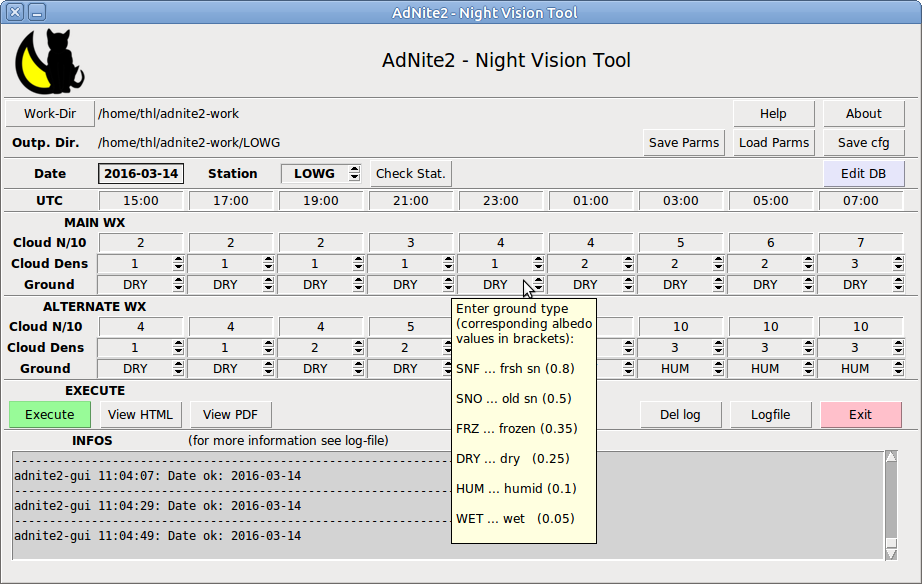
2.1.1. Buttons
Help
An offline version of this documentation will show in your
browser. The browser and the helpfile site (index.html) must be
specified in the configuration file ~/.adnite2/default.cfg.
About
Version and copyright message
Work-Dir - Button
Select the work directory under which level the actual station output directory with all the programs output is going to.
Save Parms - Button
Save a parameter file (choose a name) with all the content of the input mask for later use.
Load Parms - Button
Loads parameters from a parameter file into the form.
Save cfg - Button
Saves actual start parameters like output directory and parameter file
name to the startup file ~/.adnite2/adnite2.cfg.
Save Parms - Button
Stores the actual parameters of the form into the parameter file.
Edit DB
Start the stations database editor for ‘local’ stations entries. The content of the original station entries can be displayed but not changed.
Execute - Button
Executes all the programs and gives notice when html and pdf are finished.
View HTML - Button
View the results as html in the browser.
View pdf - Button
View the result as pdf.
Del log - Button
Delete old log files (stored in ~/.adnite2/logfiles/). The
actual log-file is not touched.
Logfile - Button
View the logfile in the browser for better understanding of possible error messages.
Exit - Button
Exit the program.
2.1.2. Entry fields
Date - Entry field
Enter the date in the format YYYY-MM-DD, e.g. May 12th 2015: 2015-05-12
Station - Spinbox
The supposedly most frequently used stations (favorite stations) can be reached by the spin box entries. The list of favorite stations can be configured in the configuration file that is read at start up. Other stations can be entered by their location indicator. Check with Check Stat. - button left of it whether it is the correct station or not.
Check Stat. - Button
Checks if the station left is valid. If not valid it displays a warning and enforces an alternate imput. Otherwise it shows a station info in the information area.
adnite2-gui 08:47:57:
LOWG     Graz - Graz Airport              Lat: 46.9911   Lon:  15.4397    340 m
Times - Entry fields
Enter UTC-times in the format mm:hh, e.g. 20:30. DO NOT ENTER 24:00! Use 00:00 instead.
Main WX
Prevailing or main cloud and surface conditions effecting night illuminance.
Alternate WX
Minimal or alternate cloud and surface conditions effecting night illuminance.
Cloud N
Clouds in tenths from 0 to 10
Cloud density
- 0
- thin clouds like Cirrus, Altocumulus translcidus, thin Stratus
- 1
- thn.m (medium thin) : single level standard clouds without precipitation and minor thickness: fog, stratus, stratocumulus, cumulus humilis, thin altocumulus, thin altostratus or thick cirrostratus.
- 2
- thk.m (medium thick): single level or thin multilevel clouds, sometimes also with drizzle or very feeble precipitation: thick fog, thick stratus, stratocumulus, cumulus mediocris, standard altocumulus, altostratus.
- 3
- Thick: nimbostratus, cumulonimbus, TCU, thick multilevel clouds, frequently associated with precipitation.tratus, multiple and dense layers of SC, AC, CU.
Ground
- DRY
- dry surfaces like grassland, crops and traffic ways.
- HUM
- humid surfaces like after rain und during drizzle and feeble rain or strong dew.
- WET
- wet surfaces during rain or rain showers and after heavy rain, also extended conifere forest
- SNO
- old snow cover, probably with some snow free spots
- SNF
- fresh snow or bright cold snow
- FRZ
- frozen fround (not snow coverd)
For choosing cloudiness, cloud density and the state of the ground make clear which effect on illuminance you expect.
2.2. adnite2-cli
‘adnite2-cli’ is a command line program for all astronomical and illuminace calculations. It works with command line options and takes input from a parameter file.
Usage
adnite2-cli -h
usage: adnite2-cli [-h] [--version] [-g] [-r] inputfile

Calculate Night Vision Data

positional arguments:
inputfile       inputfile with all relevant input data.The file must be a
csv-file with special keywords. You should have got a copy
of a sample file to see the format.

optional arguments:

     -h, --help     show this help message and exit
    --version       show program version number and copyright notice and
                    exit
    -g, --graphics  calculates basics astronomical data, moon-data
                    and illuminance data for a given location,
                    time window and environment. Input is read
                    from an inputfile.
    -r, --rst       Calculates base, moon and illumination data and
                    outputs it to an appropriate
                    ReStructuredText-file
2.3. adnite2dbedit
Extra program adnite2dbedit (License: GPL2) to list database entries and to input so called ‘private’ Stations for temporary use.
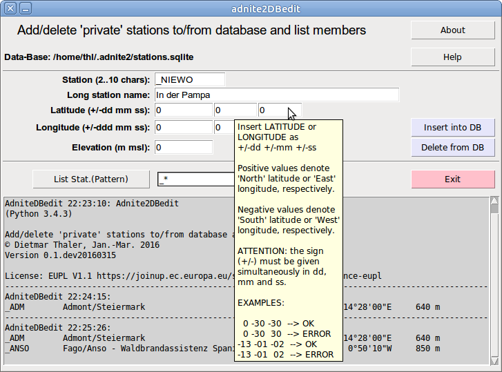
Usage:
$ adnite2dbedit -h
usage: adnite2dbedit [-h] [-a ADNITE] [-d]

optional arguments:
-h, --help            show this help message and exit
-a ADNITE, --adnite ADNITE
Environment: adnite2' or 'adnite3', defaults to
'adnite2', defines the directory and name for the
station database.
-d, --debug           Switch on output to terminal
If no default database can be found at start a file select window pops up to select a sqlite3 station data base.
Private stations must be entered with a location indicator starting with an underscore ‘_’. The name must be ASCII-clean (no Umlaut, etc …).
Coordinates are entered in arc degrees, arc minutes and arc seconds. Positiv values mean North and East, respectively. Negative values values mean South and West, respectively.
ATTENTION: the positive sign can be omitted, the negativ sign must be put in front of minutes and seconds as well. All values (degree, minute, second) must be of the same sign. Otherwise an error message will pop up while pressing the Insert into DB - Button. Entries are checked whether they are within the allowd range, messages are given at the Status-Area.
Private entries can be removed form the data base by entering the private location indicator and pressing the Delete from DB - Button.
Arbitrary stations selected by wildcards can be listed by clicking the List Stat.(Pattern) - Button.
Allowed wildcards:
- ‘*’ … arbitrary characters with arbitrary number of occurence
- ‘?’ … arbitrary character with single occurence
Searched are both Station (location indicator) and Long station name. Searching ‘*’ will list all database entries. Depending on the total number of entries this may take a while.
2.4. adnite2createdb
adnite2createdb is a command line interface program fro creation and maintenance of a station database that is based on the public domain airport station database (without any waranty!) at ourairports.com/data/.
usage: adnite2createdb [-h] -i INPUTCSV -o OUTPUTDB [-t TRUNCATE] [-c]
[--version]

Reads airport data from an csv-file in the format supplied for
the public domain at ** http://ourairports.com/data/airports.csv**
and outputs converted data into a sqlite3 database needed by the
adnite2 (or a similar) night vision program suite.

* If there is no database, the database will be created.
  If the database exists already, pre existing entries will be replaced,
  others remain untouched.

  * Location indicators are converted (from Unicode) to ASCII

  * The (long) station name consists of municipality + airport name
    (if municipality is given), otherwise of the airport name
    alone.  The name is converted to ASCII and truncated to a
    reasonable maximum length. Truncated names are indicated by
    trailing '..'.

  * Latitude and longitude is converted from decimal arc degrees to
    arc deg., arc minute and arc second where the sign of degrees
    is also shifted to to the sign of minutes and seconds
    (e.g. -13.52 deg --> -13 deg -31 min -12 sec)

  * Station height is converted from foot to meters

optional arguments:

-h, --help            show this help message and exit
-i INPUTCSV, --inputcsv INPUTCSV Input csv-file with airport data
-o OUTPUTDB, --outputdb OUTPUTDB Output sqlite3 database file.
-t TRUNCATE, --truncate TRUNCATE maximum length of long station
                                 names, defaults to 50, limited to
                                 the range 20..80
-c, --copyright       Display copyright notice and exit
--version             show program's version number and exit